
An Integrated AHP–Entropy Weighted GOD model with K-Means Clustering for Groundwater Vulnerability Mapping in Akwa Ibom State, Nigeria
DOI:
https://doi.org/10.83080/rejost.vol6no9.346Keywords:
Electrical Resistivity Tomography, Vertical Electrical Sounding, Aquifer Vulnerability Assessment, Groundwater Protection, Groundwater Vulnerability, GOD Index, Analytic Hierarchy Process (AHP), Information Entropy, K-Means Clustering, HydrogeophysicsAbstract
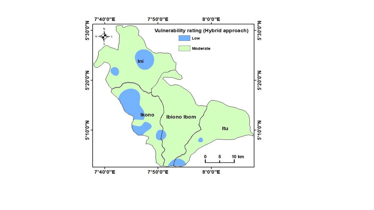
Groundwater resources in the coastal sedimentary basins of sub-Saharan Africa face severe anthropogenic threats. Conventional groundwater vulnerability overlay models, such as the GOD index, are frequently constrained by subjective parameter weighting and arbitrary index thresholding, which can produce spatial over-smoothing and broad, homogeneous vulnerability classifications. To address these limitations, this study presents an integrated hydrogeophysical framework coupling Multi-Criteria Decision Analysis (MCDA) with unsupervised machine learning. Applied to the heterogeneous coastal sedimentary aquifers of northeastern Akwa Ibom State, Nigeria (encompassing Ini, Ikono, Ibiono Ibom, and Itu LGAs), the methodology utilizes 30 1D Vertical Electrical Soundings (VES), 16 high-resolution 2D Electrical Resistivity Tomography (ERT) profiles, and deep borehole lithology logs to characterize subsurface architecture. A hybrid weighting scheme was established by combining expert-driven Analytic Hierarchy Process (AHP) weights with objective, data-dispersion Information Entropy weights. To eliminate predefined category boundaries, K-means clustering (k = 2), evaluated via the Elbow Method, was utilized to naturally partition the continuous vulnerability index into two distinct categories: moderate and low. This clustering was executed on the 30 m × 30 m raster cells encompassing the entire study area. Consequently, the classification provides a continuous spatial vulnerability assessment across the region, rather than being restricted solely to the 30 Vertical Electrical Sounding (VES) station coordinates. Internal cluster metrics (Silhouette Coefficient = 0.93; Davies–Bouldin Index = 0.14; Calinski–Harabasz Index = 791.50) confirmed strong internal separation and compactness of the model-derived clusters. In comparison, the conventional GOD model classified approximately 95% of the mapped area as Low vulnerability and 5% as Very Low/Negligible, producing a substantially more homogeneous spatial pattern. Single-Parameter Sensitivity Analysis revealed that Groundwater Occurrence (G) is the primary risk determinant (65.67% effective weight), while Overlying Strata Lithology (O) serves as a secondary localized risk regulator (22.43% effective weight). By replacing static thresholds with data-driven cluster separation, this integrated AHP–Entropy and K-means framework offers a reproducible, geophysically constrained approach to regional groundwater vulnerability assessment in complex sedimentary settings.
References
Adeyemo, I. A., Babalola, A. A. & Osinaya, T. A. (2026). Entropy-Based Integration of Geological and Geoelectrical Parameters for Groundwater Vulnerability Assessment in Oke-Aro, Akure, Nigeria. AJER, 8(1). https://doi.org/10.21124/ajer.2026.39.59
Akankpo, A. O. & Igboekwe, M. U. (2011). Monitoring Groundwater Contamination using Surface Electrical Resistivity and Geochemical methods. Journal of Water Resources and Protection. 3(5): 318-324
Akinlalu, A. A., Mogaji K. A. & Adebodun, T. S. (2021). Assessment of Aquifer Vulnerability using a developed ‘GODL’ method (modified GOD model) in a Schist belt environs, Southwestern Nigeria. Environ Monit Assess. 193, 199. https://doi.org/10.1007/s10661-021-089-60-z
Ali, M., Ali, H., Elsadek, E. A., William, C. & Thorp, K. R., Elshikha D. M. (2026). Groundwater potential mapping using machine learning technologies: current trends and future perspectives. Water, 18(8), 947
Aller, L., Bennett, T., Lehr, J. H., Petty, R. J. & Hackett, G. (1987). DRASTIC: A standardized system for evaluating ground water pollution potential using hydrogeologic settings. US Environ-mental Protection Agency, Office of Research and Development, EPA/600/2-87/035, Washington, D.C.
Amadi, A. N., Olasehinde, P. I., Okosun, E. A. & Yisa, J. (2010). Assessment of the water quality index of Otamiri and Oramiriukwu Rivers. Physics International, 1(2): 102-109.
Barzegar, R., Asghari Moghaddam, A., Nazemi, A. H., & Adamowski, J. (2019). Delimitation of groundwater zones under contamination rock using a bagged ensemble of optimized DRASTIC frameworks. Environ Sci Pollut. Res Int., 26(8): 8325-8339.
Bem, T. T., Onifade, Y. S. & Agbalagba, E. O. (2026). Application of 2-D Electrical Resistivity Tomography and Radiometric Techniques in Assessing Groundwater Vulnerability and Soil Contamination in Jos Mining Area, Nigeria. FUDMA Journal of Sciences 10(13).
Caliński, T., & Harabasz, J. (1974). A dendrite method for cluster analysis. Communications in Statistics - Theory and Methods, 3(1), 1-27.
Chiaghanam, O. I., Chiagikobi, K., Ikegwuonwu, O. N, Omoboriowo, A. O., Onyemesili, O. & Yikarebogha, Y. (2014). Sedimentology and Sequence Stratigraphy of Eocene Nanka Formation (Ameki Group): an evaluation of Ogbunike Reference Locality in Anambra Basin, Southern Nigeria. IOSR Journal of Applied Geology and Geophysics, 2(3): 01-10
Chukwuma, E. C., Okonkwo, C. C., Afolabi, O. O. D., Pham, Q. B., Anizoba, D. C., & Okpala, C. D. (2023). Groundwater vulnerability to pollution assessment: An application of geospatial techniques and integrated IRN-DEMATEL-ANP decision model. Environmental Science and Pollution Research, 30(19), 49856–49874. https://doi.org/10.1007/s11356-023-25447-1
Chukwura-Osoagba, U. O., Igwilo, P. G. & Okpara, C. C. (2025). Investigation of Hydrochemical characteristics of groundwater quality of Bogoberi in Calabar Municipality in Cross River State, Southeastern Nigeria. Disco Environ 3(48), https://doi.org/10.1007/-s44274-025-00235-5
Davies, D. L., & Bouldin, D. W. (1979). A cluster separation measure. IEEE Transactions on Pattern Analysis and Machine Intelligence, (2), 224-227.
Dobrin, M. B., and Savit, C. H. (1988). Introduction to geophysical prospecting (4th ed.). McGraw-Hill.
Ebri, E., Bassey, N.E., George, N.J. & Harry, T.A. (2025). Geochemical analysis of groundwater in Central Cross River State: implications for water quality and public health, Researchers Journal of Science and Technology, 5(2),16-38.
Echogdali, F. Z., Bendarma, A., Saidi, M. E., Aadroui. M., Albelrahman, K. (2022). Application of analytic hierarchy process (AHP) and Geophysical method for Groundwater potential mapping in the Tata Basin. Morocco water, 14:15,2393. https://doi.org/10.3390/w14152393.
Ekanem, A. M. (2022). AVI and GOD-Based vulnerability assessment of aquifer units; a case study of parts of Akwa Ibom State, Southern Niger Delta, Nigeria. Sustainable Water Resour. Manag. 8(29). https://doi.org/10.1007/s40899-022-00628-x
Ekanem, A. M., Akpan, A. E., George, N. J. & Thomas J. E. (2021). Appraisal of Protectivity and Corrosivity of Surficial Hydrogeological Units via Geo-Sounding Measurement. Environmental Monitoring and Assessment, 193(11). https://doi.org-/10.1007/s10661-021-09518-9
Ekanem, A. M., George, N. J. & Thomas, J. E. (2024a): Investigation of aquifer storage properties and groundwater contamination risk potential using an electrical resistivity technique: a sedimentary environment case study, Water Practice and Technology, 19 (8): 3350–3372, https://doi.org/10.2166/-wpt.2024.203
Ekanem, A. M., George, N. J., Thomas, J. E. & Udo, I. G. (2024b). Geophysical investigation of aquifer flow unit characteristics in northern parts of Akwa Ibom State, Southern Nigeria. Results in Earth Sciences, 2, 100017, ISSN 2211-7148, https://doi.org/10.1016/j.rines.20-24.100017.
Ekanem, A.M., Ikpe, E.O., George, N.J. & Thomas, J.E. (2024c). Integrating geoelectrical and geological techniques in GIS-based DRASTIC model of groundwater vulnerability potential in the raffia city of Ikot Ekpene and its environs, southern Nigeria. Int J Energ Water Res 8, 385–404. https://doi.org/10.1007/s42108-022-00202-3
Ekanem, K. R., George, N. J. & Ekanem, A. M. (2022). Parametric characterization, protectivity and potentiality of shallow hydrogeological units of a medium-sized housing estate, Shelter Afrique, Akwa Ibom State, Southern Nigeria. Acta Geophys. 70, 879 – 895. https://-doi.org/10.1007/s11600-022-00737-3
Ekpo, A. E., Bassey, N. E., George, N. J., & Udo, I. G. (2024). Depth to basement estimation from aerogravity data over the Southeastern part of Niger Delta region of Nigeria. Researchers Journal of Science and Technology, 4(5), 44–66. https://-doi.org/10.83080/rejost.vol4no5.135
Eni, O. C., Ossai, N. M. & Ibuot, J. C. (2024). Aquifer Vulnerability studies using Electrical Resistivity method in Nsukka East and West Local Govt. Area, Enugu State, Nigeria. International Journal of Earth Sciences and Geophysics, 10(1). DOI: 10.35840/2631-5033/1873
Foster, S. S. D. (1987). Fundamental concepts in aquifer vulnerability, pollution risk and protection strategy. In W. van Duijvenbooden & J. van Waegeningh (Eds.), Vulnerability of soil and groundwater to pollutants (pp. 69–86). TNO Committee on Hydrological Research.
George, N. J. (2021a). Geo-electrically and hydrogeologically derived vulnerability assessments of aquifer resources in the hinterland of parts of Akwa Ibom State, Nigeria, Solid Earth Sciences, 6(2), 70-79. 10.1016/j.sesci.2021.04.002.
George, N. J. (2021b). Integrating hydrogeological and second-order geo-electric indices in groundwater vulnerability mapping: A case study of alluvial environments. Appl Water Sci 11, 123. https://doi.org/10.1007/s13201-021-01437-x
George, N. J., Agbasi, O. E., Umoh, A. J., Ekanem, A. M., Udosen, N. I. & Thomas, J. E. (2025a). Enhanced Contamination Risk Assessment for Aquifer Management using the Geo-resistivity and DRASTIC Model in Alluvial settings. Cleaner water, 3: 100060. 10.1016/j.clwat.2024.100060
George, N. J., Ekanem, K. R., Ekanem A. M. & Udosen, N. (2025b). Georesistivity assessment of lithological and hydrodynamic factors in groundwater sanitation of Akwa Ibom River channel aquifer system. Geosystems and Environment, 4(3): 100411. https://doi.org/10.1016/j.geogeo.2025.100401
George, N.J., Agbasi, O.E., Umoh, A.J., Ekanem, A.M., Udosen, N.I., Thomas, J.E., Aba, M.U. & Ejepu, J.S. (2025c): Enhanced contamination risk assessment for aquifer management using the geo-resistivity and DRASTIC model in alluvial settings, Cleaner Water 3, 100060. https://doi.org/10.1016/j.clwat.-2024.100060
George, N.J. & Thomas, J.E. (2024) Typification of coastal depositional lithofacies with isophysical and isochemical hydro-sand beds via stratigraphic modified Lorenz plots (SMLP): geohydrodynamical implications and valorization of hydrogeological units. Acta Geophys. 72, 1275–1291. https://doi.org/10.1007-/s11600-023-01160-y
George, N.J., Agbasi, O.E., Umoh, J.A., Ekanem, A.M., Ejepu, J.S., Thomas, J.E. & Udoinyang, I.E. (2023). Contribution of electrical prospecting and spatiotemporal variations to groundwater potential in coastal hydro-sand beds: a case study of Akwa Ibom State, Southern Nigeria. Acta Geophys. 71, 2339–2357. https://doi.org/10.1007-/s11600-022-00994-2
George, N. J., Ekanem, K. R., Ekanem, A. M., Udosen, N. I. & Thomas, J. E. (2022a). Generic comparison of ISM and LSIT interpretation of geo-resistivity technology data, using constraints of ground truths: a tool for efficient explorability of groundwater and related resources. Acta Geophysica, 70(3), pp.1223-1239. https://doi.org/10.1007-/s11600-022-00794-8
George, N.J., Ekanem, A.M., Thomas, J.E. & Harry, T.A. (2022b): Modelling the effect of geo-matrix conduction on the bulk and pore water resistivity in hydrogeological sedimentary beddings. Modeling Earth Systems and Environment, 8 (1), 1335-1349.
George, N. J., Umoh, J. A., Ekanem, A. M., Agbasi, O. E., Jamal, A. & Thomas, J. E. (2022c). Geophysical-laboratory data integration for estimation of groundwater volumetric reserve of a coastal hinterland through optimized interpolation of interconnected geo-pore architecture. J Coast Conserv., 26, 56. https://doi.org/-10.1007/s11852-022-00902-2
George, N.J., Ekanem, A.M., Thomas, J. E. & Harry, T. A. (2022d). Modelling the effect of geo-matrix conduction on the bulk and pore water resistivity in hydrogeological sedimentary beddings. Model. Earth Syst. Environ. 8, 1335–1349. https://doi.org/-10.1007/s40808-021-01161-0
George, N.J., Ekanem, A.M., Thomas, J.E., Thomas, J.E. & Ekong, S.A. (2021) Mapping depths of groundwater-level architecture: implications on modest groundwater-level declines and failures of boreholes in sedimentary environs. Acta Geophys. 69, 1919–1932. https://doi.org/10.1007/s11600-021-00663-w.
George, N.J. (2020). Appraisal of Hydraulic Flow Units and Factors of the Dynamics and Contamination of Hydrogeological Units in the Littoral Zones: A Case Study of Akwa Ibom State University and Its Environs, Mkpat Enin L.G.A, Nigeria. Nat Resour Res., 29, 3771–3788. https://doi.org/10.1007/s11053-020-09673-9
George, N.J., Obionwu, V.I. Akpabion, G.T & Obot, I.B. (2010). Comparison of thermal insulation efficiency of some select materials used as ceiling in building design. Archives of Applied Science Research, 2(3), 253-259.
Ghazavi, R., & Ebrahimi, Z. (2019). Assessing groundwater vulnerability to contamination using a modified DRASTIC model in an arid climate. Groundwater for Sustainable Development, 8, 310–319.
Gou, T. & Yan, S. (2026). Groundwater Vulnerability Assessment Techniques. A Comparative review of models and applications. Journal of Environ and Earth Sciences, 8(8), 1218-1238.
Halder, S., Roy, M. B., Roy, P. K., & Sedighi, M. (2023). Groundwater vulnerability assessment for drinking water suitability using Fuzzy Shannon Entropy model in a semi-arid river basin. Catena, 229, Article 107206. https://doi.org/10.1016-/j.catena.2023.107206
Harry, T. A., Asuaiko, E., Akata, N. & Akpan N. (2020). Mapping Groundwater Potential Recharge Zones in parts of Akwa Ibom State using Geographic Information System (GIS). Journal of civil Engineering Research, 12(2): 60-71
Hou, M., Zhou, A. & Huang, P. (2025). Trends, Challenges, and Opportunities in Groundwater level Modelling with machine Learning. Environ. Earth Sci. 84, 615. https://doi.org/10.1007/s/266s-025-12653-y
Ikpe E. O., Ekanem, A. M., George, N. J. & Thomas, J. E. (2025a). Geophysical Assessment of Aquifer Protectivity, groundwater potential and flow dynamics in northern Akwa Ibom State, Nigeria: Implications of sustainable freshwater management. Geosystems and Geoenvironment 4(3): 100401. https://-doi.org/10.1016/j.geogeo.2025.100401
Ikpe, E.O., Ekanem, A.M., George, N.J. Thomas, J.E. & Udosen, N, I. (2025b) GOD-and DRASTIC-based valuation of groundwater vulnerability to contamination of hinterland aquifers of northern part of Akwa Ibom State, Nigeria, Results in Earth Sciences, 3, 100104, 10.1016/j.rines.2025.100104.
Inyang, N. E., Ehibor, I. U., Ekot, A. E., & Udo, I. G. (2024a). An environmental assessment and a priori implications of field investigations of older MSW at Uyo and Younger MSW at Eket, Akwa Ibom State, southern Nigeria. Researchers Journal of Science and Technology, 4(1), 45–71. https://doi.org/10.83080/rejost.-vol4no1.91
Inyang, N., George, N., Ehibor, I., Ekot., A. & Udo, I. (2024b). Ingress of municipal solid waste into water resources: an environmental assessment and monitoring tool near dumpsites in Akwa Ibom State, Nigeria. Water Practice and Technology, 19 (8): 3182–3202.
Kaufman, L., & Rousseeuw, P. J. (1990). Finding groups in data: An introduction to cluster analysis. John Wiley & Sons.
Kazakis, N., & Voudouris, K. (2017). Groundwater vulnerability and pollution risk assessment of porous aquifers to nitrate contamination using GIS and AHP techniques. Journal of Hydrology, 554, 303–318.
Lodwick, W. A., Monson, D., & Svoboda, L. (1990). Attribute error and sensitivity analysis of map operations in geographical information systems. International Journal of Geographical Information Systems, 4(4), 413–428. https://doi.org/10.1080/02698799009438561
MacDonald, A. M., Bonsor, H. C., Dochartaigh, B. É. Ó., & Taylor, R. G. (2012). Quantitative maps of groundwater resources in Africa. Environmental Research Letters, 7(2), Article 024009. https://doi.org/10.1088/1748-9326/7/2-/024009
Malakootian, M. & Nozari, M. (2020). GIS-Based DRASTIC and Composite DRASTIC Indices for Assessing Groundwater Vulnerability in the Baghin Aquifer, kerman, Iran, Nat. Hazards Earth Syst. Sci. 20, 2351-2363.
Napolitano, P., & Fabbri, A. (1996). Single-parameter sensitivity analysis for aquifer vulnerability assessment using DRASTIC and GOD. In K. Kovar & H. van der Heijde (Eds.), Calibration and reliability in groundwater modelling (pp. 559–566). IAHS Press.
Ndoma, E.G, George, N.J. Ekanem, A.M., Orosun, M.M., Ushie, P.O., Agbo, E.P., Eze, B.E., Mbonu, C. C., Adesina, K. E., Yahweh, B. & Okon, F.E. (2025). Evaluating the health risks of radionuclides in welding and fabrication workshops in Akwa Ibom State, Southern Nigeria. (2025). Journal of the Nigerian Society of Physical Sciences, 7(3), 2550. https://doi.org/10.46481-/jnsps.2025.2550
Obianwu, V., George, N. & Udofia, K. (2011). Estimation of Aquifer Hydraulic Conductivity and Effective Porosity distributions using laboratory measurements on core samples in the Niger Delta, Southern Nigeria. International Review of Physics, 5(1), 19-24.
Odesa, G., Efetobo, O., Chukwusa, F. & Okpoyibo, O. (2026). Integrated Hydrogeophysical and Hydrogeochemical Assessment of Aquifer Characteristics and Groundwater Vulnerability in parts of Asaba, Niger Delta, Nigeria. ABUAD International Journal of natural and Applied Sciences, 6(3), 14-24
Ogbe, O. B. & Osokpor, J. (2019). Depositional facies, sequence stratigraphy and reservoir potential of the Eocene Nanka Formation of the Ameki group in Agu-Awka and Umunya, Southeast Nigeria. Heliyon, 7(1), e05846.
Ojeaga, K. & Osauzou, O. (2024). Delineation of aquifer protective capacity and groundwater yield of surrounding environment of Ikpeshi, Akoko, Edo State, Nigeria. Journal of Appl. Sci. Environ. Manage., 28(10), 2971-2979.
Ortega, R. M. V., Gonzatez, O. S., Miranda, W. R. & Carreno, M. V. (2023). Data Mining to Aquifer Vulnerability Assessment. Water Conservancy, 6(1). https://doi.org/10.32629/rwc.v6i1.1203
Ozegin, K. O., Oseghale, O. I., & Ehigiator, F. I. (2024). Spatial evaluation of groundwater vulnerability using the DRASTIC-L model with the analytic hierarchy process (AHP) and GIS approaches in Edo State, Nigeria. Environmental Monitoring and Assessment, 196(6), Article 532. https://doi.org/10.1007/s10661-024-12602-5
Rashid, M., Ullah, S., Farooq, S., Haider, S., Lilo, I. S. & Parise, M. (2026). Integrated Data-driven multi-criteria Analysis and machine Learning Approaches for Assessment of Flood Susceptibility mapping. Water, 18(7), 844. https://doi.org/10.3390/w18070844
Rousseeuw, P. J. (1987). Silhouettes: a graphical aid to the interpretation and validation of cluster analysis. Journal of Computational and Applied Mathematics, 20, 53-65.
Saaty, T. L. (1980). The analytic hierarchy process: Planning, priority setting, resource allocation. McGraw-Hill.
Sartika, D., Muhni, A., Rifqan, R. & Putra, H. S. (2020). Groundwater vulnerability to pollution using the GOD method in Banda Aceh city, Aceh province. Journal of Aceh Physics Society, 9(3): 84-90.
Shannon, C. E. (1948). A mathematical theory of communication. The Bell System Technical Journal, 27(3), 379–423. https://doi.org/10.1002/j.1538-7305.19-48.tb01338.x
Thomas, J. E., George, N. J., Ekanem, A. M., & Nsikak, E. E., (2020): Electrostratigraphy and hydrogeochemistry of hyporheic zone and water-bearing caches in the littoral shorefront of Akwa Ibom State University, Southern Nigeria. Environmental monitoring and assessment, 192, (8), 505. https://doi.org/10.1007/s10661-020-08436-6
Thorndike, R. L. (1953). Who belongs in the family? Psychometrika, 18(4), 267-276.
Uche, D. I., Wendland, F., & Herd, R. (2021). Characterizing groundwater vulnerability in developing urban settings using DRASTIC-LuPa approach: A case study of Aba City, Nigeria. African Journal of Environmental Science and Technology, 15(12), 540–559. https://doi.org/10.5897/AJEST2021.3068
Udo, A. A., Ijeh, I.B., Eyenaka, F. D. & Agabi, D. A. (2019). Geoelectric investigation of groundwater potentials in Ini LGA of Akwa Ibom State, Nigeria. Journal of research and innovations in Engineering, 4(1), 59-70
Udo, I. G. & Mode, A. W. (2013). Use of Statistical Parameters in the Sedimentological Study of Conglomerate Deposits in Northeastern Part of Akwa Ibom State, Niger Delta Basin, Nigeria. IOSR Journal of Applied Geology and Geophysics (IOSR-JAGG) e-ISSN: 2321–0990, p-ISSN: 2321–0982.Volume 1, Issue 5, PP 21-27 www.iosrjournals.org
Udo, I. G., Udofia, P. A., Etukudo, N. J., & Adesina, D. A. (2023). Paleo environmental Interpretation of the Exposed Section of the Benin Formation in Southeastern Part of the Niger Delta Basin, Nigeria: A Pebble Morphometric Approach. IOSR Journal of Applied Geology and Geophysics (IOSR-JAGG) e-ISSN: 2321–0990, p-ISSN: 2321–0982.Volume 11, Issue 3 Ser. III, 12-19 www.iosrjournals.org
Udosen, N. I., Ekanem, A. M., & George, N.J. (2024a). Appraisal of flood-prone litho-stratigraphic units via geo electrical technology. Malaysian Journal of Geosciences (MJG), 8(1), 26 - 37.
Udosen, N. I., Ekanem, A.M. & George, N.J. (2024b) Geophysical exploration to assess leachate percolation and aquifer protectivity within hydrogeological units at a major open dump in Eket, Nigeria,Results in Earth Sciences, 2, 100022. 10.1016/j.rines.2024.100022.
Udosen, N. I., Ekanem, A.M. & George, N.J., Thomas J. E. (2024c). Geo-electrostratigraphic assessment of aquifer potential, protectivity, and pliable level of vulnerability within a coastal milieu, Water Practice & Technology, 19 (5), doi: 10.2166/wpt.2024.125.
Udosen, N. I., Ekanem, A. M., & Thomas, J. E. (2024d). Geo-hydraulic characterization of a coastal aquifer system in South-eastern Nigeria with the inverse slope method. Researchers Journal of Science and Technology, 4(1), 1–20. https://doi.org/-10.83080/rejost.vol4no1.82
Udosen, N.I., Ekanem, A.M. & George, N.J. (2024e). Modeling of aquifer geo-hydraulic characteristics with geo-electrical methods at a major coastal aquifer system in Uyo, southern Nigeria, Water Practice and Technology, 19 (2): 611–628.
Udosen, N.I. Ekanem, A.M. & Thomas J.E (2023). Evaluation and modeling of a major coastal aquifer’s vulnerability to contamination with the use of GOD and AVI models as indicators in South-eastern Nigeria. Researchers Journal of Science and Technology, 3 (4), 61-78.
Udosen, N.I. & George, N.J. (2018a). A finite integration forward solver and a domain search reconstruction solver for electrical resistivity tomography (ERT). Model. Earth Syst. Environ. 4, 1–12. https://doi.org/10.1007/s40808-018-0412-6.
Udosen, N.I. & George, N.J. (2018b) Characterization of electrical anisotropy in North Yorkshire, England using square arrays and electrical resistivity tomography. Geomech. Geophys. Geo-energ. Geo-resour. 4, 215–233. https://doi.org/10.1007/s40948-018-0087-5.
Ukwuani, C. C., Udom, G. J. and Giadom, F. D. (2024). Aquifer Delineation in parts of Akwa Ibom State, Southern Nigeria, Using Resistivity Survey. International Journal of Science and Research, 13(1).
Umoh, J.A., George, N.J., Ekanem, A.M. & Emah J.B. (2025). Characterization of hydro-sand beds and their hydraulic flow units by integrating surface measurements and ground truth data in parts of the shorefront of Akwa Ibom State, Southern Nigeria. Int J Energ Water Res 9, 13–29. https://doi.org/-10.1007/s42108-022-00215-y
Uwa, U.E., Akpabio, G.T. & George, N.J. (2019). Geohydrodynamic Parameters and Their Implications on the Coastal Conservation: A Case Study of Abak Local Government Area (LGA), Akwa Ibom State, Southern Nigeria. Nat Resour Res 28, 349–367. https://doi.org/10.1007/s11053-018-9391-6
Uzcategui-Salazar, M., Montalvan, -Toala, F. & Toro-Mora, R. (2026). Machine Learning Meets Hydrogeology: A K-means approach to aquifer vulnerability mapping. Disaster Risk Reduction and Management. IntechOpen. https://-doi.org/10.5772/intechopen.1014694.
Vrba, J., & Zaporozec, A. (1994). Guidebook on mapping groundwater vulnerability. International Association of Hydro-geologists.
Zavridou, E., Busico, G. & Plato, E. (2026). Quantifying the Parameters Impact in Groundwater Vulnerability Assessment for Agriculture Pollution. A Review Environ. Process, 13(22).
Downloads
Published
How to Cite
Issue
Section
License

This work is licensed under a Creative Commons Attribution-NonCommercial-ShareAlike 4.0 International License.
Unless a different licence is clearly indicated for a particular article, articles published in the journal are made available under the Creative Commons Attribution 4.0 International (CC BY 4.0) licence. This licence permits others to read, download, copy, distribute, share, adapt, and build upon the published work, including for commercial purposes, provided that appropriate credit is given to the original author(s), the article is properly cited, and any changes made to the original work are clearly indicated.