Depth to basement estimation from aerogravity data over the Southeastern part of Niger Delta region of Nigeria
Keywords:
Gravity method, hydrocarbon exploration, Mineral exploration, Niger Delta, Southeastern NigeriaAbstract
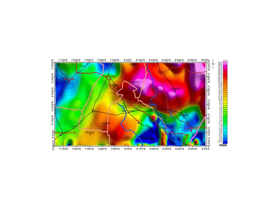
This study presents a geological interpretation of aerogravity anomalies over the southeastern part of the Niger Delta Basin, Nigeria, with a focus on identifying subsurface structures related to hydrocarbon and mineral prospecting. High-resolution aerogravity data, collected by Fugro Airborne Surveys Canada between 2005 and 2010, were processed using Oasis Montaj (v7.0.1), Surfer (v16.6), and ArcGIS (v10.4) software. The study employed various data filtering and enhancement techniques, including Fast Fourier Transform (FFT) for spectral analysis, Euler deconvolution, and 2D forward modeling. The Butterworth filter, with a central wave number of 1900 and degree 2, was used to separate regional and residual anomalies. The regional gravity anomaly map exhibited a Bouguer gravity range from -7.3 mGal to 39.4 mGal, with prominent trends in NE-SW, N-S, and NW-SE directions, indicating deep-seated subsurface structures. The residual gravity map, filtered with a central wave number of 3 and degree 8, revealed structural features including linear, ellipsoidal, and irregular-shaped anomalies extending primarily in the N-S, NE-SW, and NW-SE directions. Euler deconvolution analysis showed depth ranges from a minimum of less than 34.4 m to a maximum of over 8,228 m, identifying subsurface fault structures aligned with the prevailing lineament patterns of the Niger Delta. Radial power spectrum analysis, applied to eight subdivided blocks of the study area, identified three depth ranges: shallow, intermediate, and deep sources. The 2D forward modeling using the GM-SYS package delineated the basement topography and subsurface structures across five key profiles, revealing undulating basement features with depths varying from approximately 6,000 m to over 10,000 m. Significant geological features were identified, including a major dyke intrusion along Profile 1 and domal uplift features along Profile 2, suggesting mantle plume activity. The results indicate a complex subsurface architecture characterized by variations in rock density and structural configurations, suggesting the presence of geological conditions favorable for hydrocarbon accumulation and mineral deposits. Regions with high-frequency anomalies, characterized by the concentration of short wavelength anomalies, such as the Oban Massif, are associated with dense rock formations like granite, granodiorite, gneiss and migmatite and may contain valuable minerals and rare earth elements. The high-frequency anomalies around Ikot Ekpene, Aba, and Degema areas may be due to high density materials of lateral extent. Overall, the study demonstrates the effectiveness of using Bouguer gravity data in subsurface geological mapping and resource exploration. Blocks D1-D8 are recommended for further investigation for hydrocarbon exploration because they exhibit depths greater than 4000 m.
References
Amigun, J. O. and Ako, B. D. (2009). Rock Density-A tool for mineral prospection: A case Study of Ajabonoke Iron Ore Deposit, Okene, Southwestern Nigeria. The Pacific Journal of Science and Technology. pp. 733-741.
Bhattacharya, J., (1994). Cretaceous Dunvegan formation of the Western Canada Sedimentary Basin. In: Mossop, G.D., Shetsen, I. (comp.), Geological Atlas of the Western Canada Sedimentary Basin, Canadian Society of Petroleum Geologists and Alberta Research Council, p. 365–374.
Blakely, R.J. & Simpson, R.W., (1986) Approximating edges of source bodies from magnetic or gravity anomalies, Geophysics, 51, 1494-1498.
Ekpo, A. E., Bassey, N. E., George, N. J. (2024). Aero-gravity data analysis for delineating possible channels of mineralizations migration through lineament.A case study of Southeastern Niger Delta, Nigeria.AKSU Annels of Sustainable Development 2(1), 139-168, 2024.https://doi.org/10.60787/AASD-v2i1-35
Ekwok, S. E., Akpan, A. E. & Kudamnya, E. A., (2020). Exploratory mapping of structures controlling mineralization in Southeast Nigeria using high resolution airborne magnetic data. Journal of African Earth Sciences, 162, 103700.
Ekwok, S. E., Akpan, A. E. & Ebong, E. D. (2021). Assessment of crustal structures by gravity and magnetic methods in the Calabar Flank and adjoining areas of Southeastern Nigeria - a case study of the obudu massif. Arabian Journal of Geo-sciences, 14, 308. .https://doi.org/-10.1007/s12517-021-06696-1.
Emujakporue, G., Ofoha, C. C., Kiani, I. (2018). Investigation into the basement morphology and tectonic lineament using aeromagnetic anomalies of Parts of Sokoto Basin, North Western, Nigeria. Egyptian Journal of Petroleum, Volume 27, Issue 4, Pages 671-681, ISSN 1110-0621, https://doi.org/10-.1016/j.ejpe.2017.10.003.
Ezekiel, J. C, Onu, N. N, Akaolisa C. Z, Opara A. I. (2013). Preliminary Interpretation of gravity mapping over the Njaba sub-basin of Southeastern Nigeria. An implication to petroleum potential. Journal Geology and Mining Research, 5(3):75-87.
Garcia, J. G. and Ness, G. E., (1994). Inversion of the power spectrum from magnetic anomalies. Geophysics 59, 391–400.
Gram, C., Hanssen, P., Myrlund, E.A., and Hood P., (1965). Gradient measurements in aeromagnetic surveying. Geophysics, Volume 30, Issue 5, Pages: 705-932ISSN (print):0016-8033ISSN (online):1942-2156
Hood, P. J. & Teskey, D. J., (1989). Aeromagnetic gradiometer program of the geological survey of Canada. Geophysics, 54(8), 1012-1022.
Khamies, A. & El-Tarras, M. (2010).Surface and subsurface structures of Kalabsha area, southern Egypt, from remote sensing, aeromagnetic and gravity data. World Pumps, 13.43-52. 10.1016/j.ejrs.-2010.07.006.
Lawson, C. L., Hanson, R. J. (1974). Solving Least Squares Problems. Prentice-Hall, Englewood Cliffs. Milligan, P. & Gunn, P., (1997). Enhancement and presentation of airborne geophysical data. AGSO Journal of Australian Geology and Geophysics, 17 (2), 63–75.
Murphy, B. S. (2007). Airborne Geophysics and the Indian scenario. Journal of Industrial Geophysics, 11(1): 1-28.
Obiora, D. N, Ossai, M. N, Okeke, F. N, Oha, A. I. (2016). Interpretation of airborne geophysical data of Nsukka area, Southerneastern Nigeria.Journal of the Geological Society of India. 88:654-667.
Odek, A., Otieno, A. B., Ambusso, W. J. and Githiri, J. G., (2012). 2d-Euler deconvolution and forward modeling of gravity data of homa-hills geothermal prospect, kenya. Journal of Agriculture, Science and Technology, Vol. 15(1)
Okiwelu, A. A, ofrey-Kulo, O, Ude, I. A. (2013). Interpretation of regional magnetic data offshore Niger Delta reveals relationship between deep basement architecture and hydrocarbon target. Earth Science Research, 2(1):13-32.
Okpoli, C. C. and Akingboye, A. S. (2019). Application of high-resolution gravity data for litho-structural and depth characterisation around Igabi area, Northwestern Nigeria, NRIAG. Journal of Astronomy and Geophysics, 8:1, 231-241, DOI: -10.1080/20909977.2019.1689629
Rasmussen, R. and Pedersen, L.B. (1979) End Corrections in Potential Field Modeling. Geophysical Prospecting, 27, 749-760. https://doi.org-/10.1111/-j.1365-2478.1979.tb00994.x
Reeves, C., Reford, S., & Millingan, P., (1997). Airborne geophysics: old methods, new images. In: Gubins, A. (Ed.), Proceedings of the Fourth Decennial International Conference on Mineral Exploration, 13 – 30
Roest, W. R., Verhoef, J., Pilkington, M., (1992). Magnetic interpretation using the 3-D analytic signal. Geophysics, 57(1), 116-125.
Smith, J., and Johnson, M. (2020). Tectonic Evolution and Geodynamics of the Niger Delta Basin: Insights from Gravity Data Analysis. Journal of Geophysical Research, 125(8), 1582-1595. Doi: 10.1029/jgrb215825.
Smith, R. S., Thurston, J. B., Dai, Ting-fan, and MacLeod, L.N. (1998). The Improved Source Parameter Imaging Method: Geophysical Prospecting, Vol. 46, pp. 141-151.
Spector, A., Grant, F. S., (1970). Statistical models for interpreting aeromagnetic data. Geophysics, 35, 293–302.
Talwani, M., Heirtzler, J. R., (1964).Computation of magnetic anomalies caused by two dimensional structures of arbitrary shape. In: Computers in the mineral industries. Part 1: Stanford University Publications, Geological Sciences, 9, 464–480.
Talwani, M., Worzel, J. L. and Landisman, M., (1959). Rapid gravity computations for 2 dimensional bodies with application to the Mendocino submarine fracture zone. Journal of Geophysical Research, 64, 49-59.
Thompson, D. T. (1982). EULDPH-A New Technique for Making Computer Estimates from Magnetic Data. Geophysics, 47:31-37.
Thurston, J. B. & Smith, R. S., (1997). Automatic conversion of magnetic data to depth, dip, and susceptibility contrast using SPITM method. Geophysics, 62, 807-813.
Tuttle, M., Charpentier, R., and Brownfield, M., (2015). "The Niger Delta Petroleum System: Niger Delta Province, Nigeria, Cameroon, and Equatorial Guinea, Africa". United States Geologic Survey. United States Geologic Survey. Retrieved 6 March 2015.
Verduzco, B., Fairhead, J. D. Green, C. M. and MacKenzie, C., (2004).New insights into magnetic derivatives for structural mapping. The Leading Edge, 23, 116–119.
Won, I. J. and Bevis, M. (1987). Computing the Gravitational Magnetic Anomalies Due to a Polygon: Algorithm and FORTRAN Subroutines. Geophysics, 52, 232-238. https://doi.org/10.1190-/1.1442298
Zhang C, Mushayandebvu, M. F., Reid A. B., Fairhead J. D. and Odegard M. E. (2000). Euler De-convolution of Gravity Tensor Gradient Data. Geophysics, 65:512-520.

Downloads
Published
How to Cite
Issue
Section
License
Copyright (c) 2024 Researchers Journal of Science and Technology

This work is licensed under a Creative Commons Attribution-NonCommercial-NoDerivatives 4.0 International License.


