Assessment of Slope Dynamics and Land Use Impact on Groundwater Recharge and Flood Risks: a case study of Bayelsa State, Niger Delta
Keywords:
GIS analysis, Hydrological processes, Niger Delta, UrbanizationAbstract
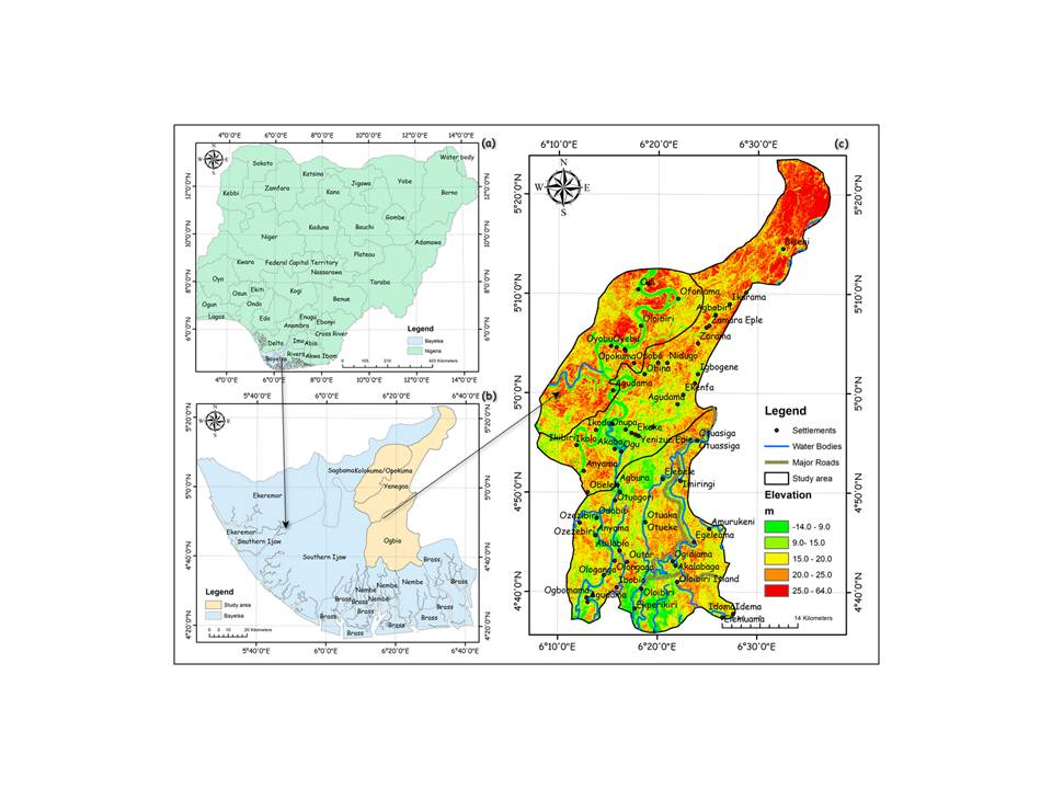
The Niger Delta region of Nigeria, characterized by low-gradient terrain, significantly influences groundwater dynamics and flood risks. This study focuses on the Kolokuma/Opokuma, Ogbia, and Yenagoa areas in Bayelsa State to assess the implications of slope variations and land use on these hydrological processes. Geographic Information System (GIS) techniques were utilized to analyze slope degrees, slope length and steepness factors, and Land Use and Land Cover (LULC) types across the study region. Slope analysis determined the distribution of slope degrees and steepness factors, while LULC analysis identified the dominant land cover types and their influence on hydrological processes. Slope analysis revealed that approximately 38.5% of the study area has a slope degree of 0 - 1.67°, indicating predominantly flat terrain. The steepness analysis showed that 94.5% of the area falls within the lowest category of steepness factors (0.00 - 6.77). LULC analysis highlighted that tree cover dominates (1625.45 km²), promoting groundwater recharge, while built-up areas (127.96 km²) contribute to increased flood risks. The findings emphasize the vulnerability of the region to flooding due to low-gradient slopes and significant built-up areas that reduce infiltration. The dominance of tree cover benefits groundwater recharge, but urban impermeable surfaces exacerbate flood risks, particularly in Yenagoa. This study underscores the need for integrated land use and flood management strategies in Bayelsa State to balance groundwater recharge with flood mitigation, highlighting the importance of preserving natural land cover for hydrological stability.
References
Adebayo, T. B., Abegunrin, T. P., Awe, G. O., Are, K. S., Guo, H., Onofua, O. E., Adegbola, G. A., & Ojediran, J. O. (2021). Geospatial mapping and suitability classification of groundwater quality for agriculture and domestic uses in a Precambrian basement complex. Groundwater for Sustainable Development, 12, 100497. https://doi.-org/10.1016/j.gsd.2020.100497
Afolabi, O., Aigbokhan, O., Mephors, J., & Oloketuyi, A. (2021). Assessment of Land Use/Cover Change Using Remote Sensing and GIS Techniques: A Case of Osogbo and Its Peripheral Areas in Nigeria. Journal of Applied Science and Environmental Management, 25(4), 543–548. https://doi.org/10.4314-/jasem.v25i4.8
Aisabokhae, J., & Osazuwa, I. (2021). Radiometric mapping and spectral based classification of rocks using remote sensing data analysis: The Precambrian basement complex, NW Nigeria. Remote Sensing Applications Society and Environment, 21, 100447. https://doi.org/10.1016/j.rsase.2020.100447
Akaolisa, C. C., Agbasi, O. E., Etuk, S. E., Adewumi, R., & Okoli, E. A. (2023). Evaluating the Effects of Real Estate Development in Owerri, Imo State, Nigeria: Emphasizing Changes in Land Use/Land Cover (LULC). Journal of Landscape Ecology, 16(2), 98–113. https://doi.org/10.2478/jlecol-2023-0012
Aladejana, J. A., Kalin, R. M., Sentenac, P., & Hassan, I. (2020). Assessing the Impact of Climate Change on Groundwater Quality of the Shallow Coastal Aquifer of Eastern Dahomey Basin, Southwestern Nigeria. Water, 12(1), 224. https://doi.org/10.3390/w12010224
Aluko, O. E., & Igwe, O. (2017). An integrated geomatics approach to groundwater potential delineation in the Akoko-Edo Area, Nigeria. Environmental Earth Sciences, 76(6). https://doi.org/10.1007-/s12665-017-6557-1
Amadi, A. (2020). Geo-Characterisation of Highway Construction Cost Drivers in the Niger Delta Region of Nigeria. Civil Engineering Research Journal, 10(2). https://doi.org/10.19080/cerj.2020.10.555785
Ampe, E. M., Vanhamel, I., Salvadore, E., Dams, J., Bashir, I., Demarchi, L., Chan, J. C., Sahli, H., Canters, F., &Batelaan, O. (2012). Impact of Urban Land-Cover Classification on Groundwater Recharge Uncertainty. IEEE Journal of Selected Topics in Applied Earth Observations and Remote Sensing, 5(6), 1859–1867. https://doi.-org/10.1109/jstars.2012.2206573
Ashaolu, E. D., Olorunfemi, J. F., & Ifabiyi, I. P. (2019). Effect of Land Use/Land Cover Change on Groundwater Recharge in Osun Drainage Basin, Nigeria. Journal of Geology Geography and Geoecology, 28(3), 381–394. https://doi.org/10.15421/111936
Bircher, P., Liniger, H., & Prasuhn, V. (2019). Comparing different multiple flow algorithms to calculate RUSLE factors of slope length (L) and slope steepness (S) in Switzerland. Geomorphology, 346, 106850. https://doi.org/10.1016/-j.geomorph.2019.106850
Brisibe, W. G., & Pepple, T. D. (2018). Lessons Learnt from the 2012 Flood Disaster: Implications for Post-flood Building Design and Construction in Yenagoa, Nigeria. Civil Engineering and Architecture, 6(3), 171–180. https://doi.-org/10.13189/cea.2018.060307
Brito, L. K. S., Costa, M. E. L., & Koide, S. (2020). Assessment of the Impact of Residential Urban Patterns of Different Hillslopes on Urban Drainage Systems and Ecosystem Services in the Federal District, Brazil. Sustainability, 12(14), 5859. https://doi.org/10.3390/su12145859
Chattaraj, D., Paul, B., & Sarkar, S. (2021). Integrated Multi-parametric Analytic Hierarchy Process (AHP) and Geographic Information System (GIS) based Spatial modelling for Flood and Water logging Susceptibility Mapping: A case study of English Bazar Municipality of Malda, West Bengal, India. https://doi.org/10.5194/nhess-2020-399
Chen, J., Li, Z., Xiao, H., Ning, K., & Tang, C. (2021). Effects of land use and land cover on soil erosion control in southern China: Implications from a systematic quantitative review. Journal of Environmental Management, 282, 111924. https://doi.org/10.1016/j.-jenvman.2020.111924
Chioma, O. C., Chitakira, M., Olanrewaju, O. O., & Louw, E. (2019). Impacts of flood disasters in Nigeria: A critical evaluation of health implications and management. Jàmbá Journal of Disaster Risk Studies, 11(1). https://-doi.org/10.4102/jamba.v11i1.557
Comegna, L., Picarelli, L., & Urciuoli, G. (2020). Effects of Slope Movements on Soil Structure and Hydrological Response. Geotechnical and Geological Engineering, 38(5), 5633–5647. https://-doi.org/10.1007/s10706-020-01341-2
Dai, Q., Peng, X., Wang, P., Li, C., & Shao, H. (2018). Surface erosion and underground leakage of yellow soil on slopes in karst regions of southwest China. Land Degradation and Development, 29(8), 2438–2448. https-://doi.org/10.1002/ldr.2960
Dan-Jumbo, N. G., Metzger, M. J., & Clark, A. P. (2018). Urban Land-Use Dynamics in the Niger Delta: The Case of Greater Port Harcourt Watershed. Urban Science, 2(4), 108. https://doi.org-/10.3390/urbansci2040108
Dean, J. F., Webb, J. A., Jacobsen, G. E., Chisari, R., & Dresel, P. E. (2015). A groundwater recharge perspective on locating tree plantations within low-rainfall catchments to limit water resource losses. Hydrology and Earth System Sciences, 19(2), 1107–1123. https://doi.org/10.5194/hess-19-1107-2015. earthexplorer.usgs.gov
Erebi, J. L., Rowland, E. D., & Etta, B. A. (2020). Remote Sensing Techniques in the Investigation of Polluted Soils at Illegal Dumpsites in Yenagoa Metropolis, Bayelsa State, Nigeria. Sumerianz Journal of Scientific Research, 311, 141–146. https://doi.org-/10.47752/sjsr.311.141.146
He, Z., Xiao, P., Yu, X., Hao, S., Jia, G., & Yang, C. (2022). A Field Study for the Effects of Grass Cover, Rainfall Intensity and Slope Length on Soil Erosion in the Loess Plateau, China. Water, 14(14), 2142. https://doi.org-/10.3390/w14142142. https://living-atlas.arcgis.com/en/apps/
Idowu, N., & Zhou, N. (2019). Performance Evaluation of a Potential Component of an Early Flood Warning System—A Case Study of the 2012 Flood, Lower Niger River Basin, Nigeria. Remote Sensing, 11(17), 1970. https://doi.org/-10.3390/rs11171970
Igwe, O. (2015). The geotechnical characteristics of landslides on the sedimentary and metamorphic terrains of South-East Nigeria, West Africa. Geoenvironmental Disasters, 2(1). https://doi.org/10.1186/s40677-014-0008-z
Ijioma, U. D. (2021). Delineating the impact of urbanization on the hydrochemistry and quality of groundwater wells in Aba, Nigeria. Journal of Contaminant Hydrology, 240, 103792. https://doi.org-/10.1016/j.jconhyd.2021.103792
Karo, O. K., Egobueze, F. E., &Egirani, D. E. (2019). Application of GIS in the Assessment of Groundwater Quality in the Yenagoa Watershed of the Niger Delta Region of Nigeria. Asian Journal of Physical and Chemical Sciences, 1–15. https://doi.org/10.9734/ajopacs/20-19/v7i230093
Kenibolayefa, M. O., & Innocent, M. A. (2018). Urban road and on-street parking in Niger Delta Region of Yenagoa, Bayelsa State, Nigeria. Journal of Geography and Regional Planning, 11(11), 166–171. https://doi.org/10.5897/jgrp2018.0706
Kouadio, K. E., Abrakasa, S., Ikiensikimama, S. S., & Botwe, T. (2020). Source Rocks Characterization of Agbada and Akata Formations In The Niger Delta, Nigeria. European Journal of Environment and Earth Sciences, 1(4). https://doi.org-/10.24018/ejgeo.2020.1.4.38
Olokeogun, O. S., Ayanlade, A., & Popoola, O. O. (2020). Assessment of riparian zone dynamics and its flood-related implications in Eleyele area of Ibadan, Nigeria. ENVIRONMENTAL SYSTEMS RESEARCH, 9(1). https://doi.org/10-.1186/s40068-020-00167-4
Olorunfemi, I. E., Fasinmirin, J. T., Olufayo, A. A., & Komolafe, A. A. (2018). GIS and remote sensing-based analysis of the impacts of land use/land cover change (LULCC) on the environmental sustainability of Ekiti State, southwestern Nigeria. Environment Development and Sustainability, 22(2), 661–692. https://doi.org/10.1007/s106-68-018-0214-z
Olorunfemi, I. E., Komolafe, A. A., Fasinmirin, J. T., Olufayo, A. A., & Akande, S. O. (2020). A GIS-based assessment of the potential soil erosion and flood hazard zones in Ekiti State, Southwestern Nigeria using integrated RUSLE and HAND models. CATENA, 194, 104725. https://doi.org/10.1016/j.catena.2020.104725
Onu, B., Price, T., Surendran, S. S., &Timbiri, A. (2013). Peoples’ Perception on the Effects of Floods in the Riverine Areas of Ogbia Local Government Area of Bayelsa State, Nigeria. Knowledge Management an International Journal, 12(2), 21–44. https://doi.org/10.18-848/2327-7998/cgp/v12i02/50793
Ren, D., Xu, X., Engel, B., Huang, Q., Xiong, Y., Huo, Z., & Huang, G. (2019). Hydrological complexities in irrigated agro-ecosystems with fragmented land cover types and shallow groundwater: Insights from a distributed hydrological modeling method. Agricultural Water Management, 213, 868–881. https:-//doi.org/10.1016/j.agwat.2018.12.011
Verma, P., Singh, P., & Srivastava, S. K. (2020). Development of spatial decision-making for groundwater recharge suitability assessment by considering geoinformatics and field data. Arabian Journal of Geosciences, 13(8). https://-doi.org/10.1007/s12517-020-05290-1
Wang, C., Shan, L., Liu, X., Yang, Q., Cruse, R. M., Liu, B., Li, R., Zhang, H., & Pang, G. (2020). Impacts of horizontal resolution and downscaling on the USLE LS factor for different terrains. International Soil and Water Conservation Research, 8(4), 363–372. https://doi.org/10.1016/j.iswcr.2020.08.001
Week, D. A., & Wizor, C. H. (2020). Effects of Flood on Food Security, Livelihood and Socio-economic Characteristics in the Flood-prone Areas of the Core Niger Delta, Nigeria. Asian Journal of Geographical Research, 1–17. https:-//doi.org/10.9734/ajgr/2020/v3i130096
Zhang, X., Kang, A., Ye, M., Song, Q., Lei, X., & Wang, H. (2023). Influence of Terrain Factors on Urban Pluvial Flooding Characteristics: A Case Study of a Small Watershed in Guangzhou, China. Water, 15(12), 2261. https://doi.org/10.3390-/w15122261
Zhao, J., Wang, Z., Dong, Y., Yang, Z., &Govers, G. (2022). How soil erosion and runoff are related to land use, topography and annual precipitation: Insights from a meta-analysis of erosion plots in China. The Science of the Total Environment, 802, 149665. https://-doi.org/10.1016/j.scitotenv.2021.149665

Downloads
Published
How to Cite
Issue
Section
License
Copyright (c) 2024 Researchers Journal of Science and Technology

This work is licensed under a Creative Commons Attribution-NonCommercial-NoDerivatives 4.0 International License.


