Impact of Drainage Density and Geological Factors on Flood Risk: A Comprehensive Study of Abia State
Keywords:
Hydrological Modeling, Rainfall Distribution, Slope Analysis, Spatial AnalysisAbstract
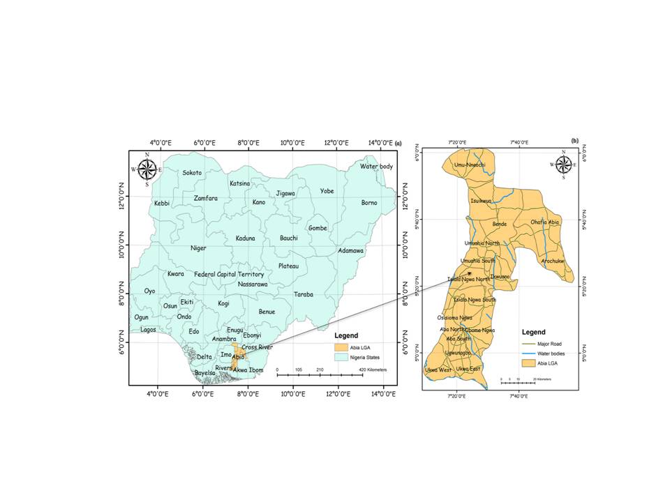
Abia State in Southeastern Nigeria is characterized by diverse topography, variable rainfall, and significant urbanization, all contributing to its flood risk profile. This study aims to assess flood risk across Abia State by analyzing drainage density, slope, land use/land cover (LULC), rainfall distribution, and proximity to water bodies to categorize flood risk levels and provide insights for targeted flood mitigation. A comprehensive spatial analysis was conducted using data on drainage density, slope, LULC, rainfall, and proximity to rivers. Drainage density was classified into five categories, and areas were mapped to highlight varying flood risk levels. Slope data helped determine terrain's influence on runoff, while LULC data assessed the impact of urbanization and vegetation on flood susceptibility. Rainfall patterns were analyzed to identify regions prone to flooding, and the relationship between proximity to water bodies and flood risk was also evaluated. Results revealed that 50.07% of Abia State is at moderate flood risk, 53.46% at high flood risk, and 34.41% at very high flood risk. High-risk areas are characterized by dense drainage networks, steep slopes, significant rainfall, and close proximity to water bodies. Aba North, Aba South, and Oboma Ngwa are among the most vulnerable regions, while areas with low drainage density and gentle slopes are the least prone to flooding. The study underscores the importance of improved drainage infrastructure, urban planning, and flood management, particularly in high-risk zones. The findings provide critical insights for enhancing resilience and mitigating the impacts of flooding in Abia State, offering a novel approach to regional flood risk assessment.
References
Akaolisa, C. C., Agbasi, O. E., Etuk, S. E., Adewumi, R., & Okoli, E. A. (2023). Evaluating the Effects of Real Estate Development in Owerri, Imo State, Nigeria: Emphasizing Changes in Land Use/Land Cover (LULC). Journal of Landscape Ecology, 16(2), 98–113. https://doi.org/10.2478/jlecol-2023-0012
Alam, A., Ahmed, B., & Sammonds, P. (2021). Flash flood susceptibility assessment using the parameters of drainage basin morphometry in SE Bangladesh. Quaternary International, 575–576, 295–307. https://doi.org/10.1016/j.-quaint.2020.04.047
Chukwuma, E., Okonkwo, C., Ojediran, J., Anizoba, D., Ubah, J., & Nwachukwu, C. (2021). A GIS based flood vulnerability modelling of Anambra State using an integrated IVFRN-DEMATEL-ANP model. Heliyon, 7(9), e08048. https://doi.org/10.1016-/j.heliyon.2021.e08048
Echendu, A. J. (2020). The impact of flooding on Nigeria’s sustainable development goals (SDGs). Ecosystem Health and Sustainability, 6(1). https://doi.org/10.-1080/20964129.2020.1791735
Egbueri, J. C., & Igwe, O. (2020). The impact of hydrogeomorphological characteristics on gullying processes in erosion-prone geological units in parts of southeast Nigeria. Geology Ecology and Landscapes, 5(3), 227–240. https://doi.org/10.1080/24749508.2020.1711637
Ekeu-Wei, I. T., & Blackburn, A. G. (2020). Catchment-Scale Flood Modelling in Data-Sparse Regions Using Open-Access Geospatial Technology. https://-doi.org/10.20944/preprints202007.0207.v1
Frey, S., Miller, K., Khader, O., Taylor, A., Morrison, D., Xu, X., Berg, S., Hwang, H. T., Sudicky, E., &Lapen. (2021). Evaluating landscape influences on hydrologic behavior with a fully-integrated groundwater – surface water model. Journal of Hydrology, 602, 126758. https://doi.org/10.1016/j-.jhydrol.2021.126758
Gabriel, A. T., Yusuf, M. B., Bwadi, B. E., & Clement, Y. G. (2020). Morphometric Analysis and Flash Floods Assessment of River Taraba Basin in Taraba State, Nigeria. European Scientific Journal ESJ, 16(20). https://doi.org/10.19044-/esj.2020.v16n20p158
Gallage, C., Abeykoon, T., & Uchimura, T. (2021). Instrumented model slopes to investigate the effects of slope inclination on rainfall-induced landslides. SOILS AND FOUNDATIONS, 61(1), 160–174. https://doi.org/10.1016/j.sandf.2020.11.006. High-resolution gridded -datasets (uea.ac.uk) https://www.usgs.gov/
Ighile, E. H., & Shirakawa, H. (2020). A STUDY ON THE EFFECTS OF LAND USE CHANGE ON FLOODING RISKS IN NIGERIA. Geographia-Technica, 15(1), 91–101. https://doi.org/10.21163/gt_2020.151.08
Ijaware, V. (2020). GIS based Flood Vulnerability Studies for Ife Central Local Government Area, Osun State, Nigeria. Deleted Journal, 4(1), 160–171. https://doi.org/10.36263-/nijest.2020.01.0184
Isagba, E. S., Izinyon, O. C., Emeribe, C. N., Uwadia, N. O., & Ezeh, C. U. (2021). Estimation of stream discharge of ungauged basins using NRCS-CN and remote sensing methods: A case study of Okhuwan and Okhaihe catchments, Benin City, Edo State, Nigeria. International Journal of Water Resources and Environmental Engineering, 13(3), 165–183. https://-doi.org/10.5897/ijwree2021.1014
Komolafe, A. A., Awe, B. S., Olorunfemi, I. E., & Oguntunde, P. G. (2020). Modelling flood-prone area and vulnerability using integration of multi-criteria analysis and HAND model in the Ogun River Basin, Nigeria. Hydrological Sciences Journal, 65(10), 1766–1783. https://doi.org/10.-1080/02626667.2020.1764960
Kudamnya, E. A., Edet, A., & Ekwere, A. S. (2021). Analysing principal components of physiographic factors affecting groundwater occurrences within Keffi, North¬-Central Nigeria. The Egyptian Journal of Remote Sensing and Space Science, 24(3), 665–674. https://doi.-org/10.1016/j.ejrs.2021.08.005
Mahmoud, M. I., Duker, A., Conrad, C., Thiel, M., & Ahmad, H. S. (2016). Analysis of Settlement Expansion and Urban Growth Modelling Using Geoinformation for Assessing Potential Impacts of Urbanization on Climate in Abuja City, Nigeria. Remote Sensing, 8(3), 220. https://doi.org/-10.3390/rs8030220
Mashi, S. A., Inkani, A. I., Obaro, O., & Asanarimam, A. S. (2020). Community perception, response and adaptation strategies towards flood risk in a traditional African city. Natural Hazards, 103(2), 1727–1759. https://-doi.org/10.1007/s11069-020-04052-2
Mohanty, M. P., Nithya, S., Nair, A. S., Indu, J., Ghosh, S., Bhatt, C. M., Rao, G. S., & Karmakar, S. (2020). Sensitivity of various topographic data in flood management: Implications on inundation mapping over large data-scarce regions. Journal of Hydrology, 590, 125523. https://doi.org/10.-1016/j.jhydrol.2020.125523
Mueller, E. R., & Grams, P. E. (2021). A Morphodynamic Model to Evaluate Long‐Term Sandbar Rebuilding Using Controlled Floods in the Grand Canyon. Geophysical Research Letters, 48(9). https://doi.org/10.1029/2021gl093007
Njoku, C. G., Efiong, J., & Ayara, N. a. N. (2020). A Geospatial Expose of Flood-Risk and Vulnerable Areas in Nigeria. International Journal of Applied Geospatial Research, 11(3), 87–110. https://doi.org/10.4018/ijagr.20200701.oa1
Obi, R., Nwachukwu, M. U., Okeke, D. C., & Jiburum, U. (2021). Indigenous flood control and management knowledge and flood disaster risk reduction in Nigeria’s coastal communities: An empirical analysis. International Journal of Disaster Risk Reduction, 55, 102079. https://doi.org/10.1016/j.ijdrr.2021.102079
Ogarekpe, N. M., Obio, E. A., Tenebe, I. T., Emenike, P. C., & Nnaji, C. C. (2020). Flood vulnerability assessment of the upper Cross River basin using morphometric analysis. Geomatics Natural Hazards and Risk, 11(1), 1378–1403. https://doi.org/10.1080/-19475705.2020.1785954
Ogungbade, O., Ariyo, S. O., Alimi, S. A., Alepa, V. C., Aromoye, S. A., & Akinlabi, O. J. (2022). A combined GIS, remote sensing and geophysical methods for groundwater potential assessment of Ilora, Oyo central, Nigeria. Environmental Earth Sciences, 81(3). https://doi.org/10.1007/s12665-022-10199-x
Olabode, O. F., Oluwaniyi, O. E., Adebayo, Q. A., & Asiwaju-Bello, Y. A. (2020). Morpho-lithostructural analysis of Ala River basin for flood risk assessment: geospatial techniques intervention. Earth Science Informatics, 13(3), 773–794. https://doi.org/10.1007/s12145-020-00457-6
Olla, O. O., Adeniran, K. A., Kasali, M. Y., & James, D. (2020). Determination of Physiographic Characteristics of an Ungauged Watershed in North Central Nigeria. IOP Conference Series Earth and Environmental Science, 445(1), 012026. https://doi.org/10.1088/1755-1315/445/1/012026
Rowland, E. D., & Okpobiri, O. (2021). Floodplain Mapping and Risks Assessment of the Orashi River Using Remote Sensing and GIS in the Niger Delta Region, Nigeria. Journal of Geographical Research, 4(2), 10–16. https://doi.org/10.30564/jgr.v4i2.3014
Sikakwe, G. U. (2020). Geospatial applications in delineating groundwater prospect zones in a hard rock terrain: an integrated approach. Environmental Earth Sciences, 79(21). https://doi.org-/10.1007/s12665-020-09235-5
Tirpak, R. A., Winston, R. J., Feliciano, M., Dorsey, J. D., & Epps, T. H. (2021). Impacts of permeable interlocking concrete pavement on the runoff hydrograph: Volume reduction, peak flow mitigation, and extension of lag times. Hydrological Processes, 35(4). https://doi.org/10.1002/hyp.14167
Tsyganskaya, V., Martinis, S., & Marzahn, P. (2019). Flood Monitoring in Vegetated Areas Using Multitemporal Sentinel-1 Data: Impact of Time Series Features. Water, 11(9), 1938. https://doi.org/-10.3390/w11091938
Wang, J., & Chen, L. (2021). The effect of hillslope geometry on Hortonian rainfall-infiltration-runoff processes. Journal of Hydrology, 594, 125962. https://doi.org/10.1016/j.jhydrol.2021.125962

Downloads
Published
How to Cite
Issue
Section
License
Copyright (c) 2024 Researchers Journal of Science and Technology

This work is licensed under a Creative Commons Attribution-NonCommercial-NoDerivatives 4.0 International License.


