
A Hybrid AHP-Entropy and K-Means DRASTIC Framework for Geoelectrical-Based Groundwater Vulnerability Mapping in Akwa Ibom State, Nigeria
DOI:
https://doi.org/10.83080/rejost.vol6no8.329Keywords:
Groundwater Vulnerability, DRASTIC Index, Electrical Resistivity Tomography, Shannon’s Information Entropy, K-Means Clustering, Sensitivity Analysis, Niger DeltaAbstract
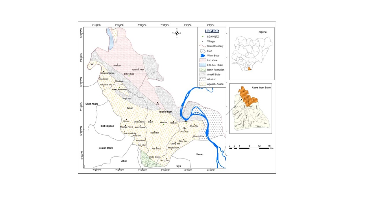
The assessment of groundwater vulnerability to anthropogenic contamination is critical for water resource management, yet traditional empirical overlay index models like DRASTIC suffer from rigid subjective weightings and arbitrary hazard classifications that fail to capture spatial heterogeneity. To overcome these limitations, this study develops and evaluates an integrated hydrogeophysical framework that combines AHP-entropy weighting with unsupervised K-means clustering within the DRASTIC model. A comprehensive field survey comprising 30 Vertical Electrical Sounding (VES) stations and 16 high-resolution 2D Electrical Resistivity Tomography (ERT) profiles was conducted across a complex structural transition zone within the southeastern extension of the Niger Delta Basin, Nigeria (covering Itu, Ibiono Ibom, Ikono, and Ini Local Government Areas). The geoelectric models were tightly constrained by local deep borehole lithology logs to differentiate protective clay aquitards from highly transmissive, vulnerable sand units. Substantive framework optimization was achieved using a hybrid Multi-Criteria Decision Analysis and Machine Learning (MCDA-ML) approach, multiplying expert-derived Analytic Hierarchy Process (AHP) weights with objective spatial variance coefficients derived from Shannon’s Information Entropy. To establish objective groundwater vulnerability zones, the K-means clustering algorithm was applied to the final continuous DRASTIC vulnerability index scores. Rather than relying on subjective manual thresholding, K-means was utilized to naturally partition the continuous vulnerability index into three distinct categories: low, moderate, and high vulnerability. This clustering was executed on the 30 m × 30 m raster cells encompassing the entire study area. Consequently, the classification provides a continuous spatial vulnerability assessment across the region, rather than being restricted solely to the 30 Vertical Electrical Sounding (VES) station coordinates. This processing was validated using the Elbow Method, Silhouette Coefficient (0.62), Calinski-Harabasz Index (108.03), and Davies-Bouldin Index (0.44). High-vulnerability hotspots were isolated in the southern plain sand corridors where highly porous sand matrices offer negligible contaminant attenuation. Moderate vulnerability constitutes the dominant regional background matrix covering intermediate terrains. Isolated low-vulnerability shields were mapped in the northern sector, geologically sustained by dense, low-permeability clay-rich lenses within the Ameki and Imo Shale Formations. The Impact of the Vadose Zone exhibited the highest mean effective weight in the single-parameter analysis, indicating strong localized influence on the vulnerability index. Depth to Water (with Maximum effective weight of 54.72%), exhibited the highest mean sensitivity in the map-removal analysis, indicating that it was the most influential parameter in the overall index under the adopted weighting scheme. Conversely, Hydraulic Conductivity perfectly stabilized at 0.00% variation across both diagnostic routines (Map Removal Sensitivity Analysis and Single-Parameter Sensitivity Analysis), demonstrating that the hybrid methodology successfully neutralized non-informative spatial parameters. The resulting field-calibrated framework provides a potentially transferable approach for groundwater vulnerability assessment and aquifer protection in heterogeneous sedimentary basins.
References
Akankpo, A. O., Igboekwe, M. U., & Udoinyang, I. E. (2018). Hydro-geophysical investigation of groundwater potential in parts of Akwa Ibom State, Southeastern Nigeria. Journal of Applied Sciences and Environmental Management, 22(4), 511–517.
Al-Adamant, K., Othman, A., & Ibrahim, M. (2003). Groundwater vulnerability mapping of the Gaza Strip using GIS. Journal of Environmental Management, 69(4), 389 – 398.
Aller, L., Bennett, T., Lehr, J. H., Petty, R. J., & Hackett, G. (1987). DRASTIC: A standardized system for evaluating ground water pollution potential using hydrogeologic settings. US Environmental Protection Agency, Office of Research and Development, EPA/600/2-87/035, Washington, D.C.
Amiri, V., Rezaei, M., & Kujawski, W. (2020). A critical review on the use of GIS-based water quality indices (WQIs) in groundwater. Ecological Indicators, 115, Article 106368.
Asfahani, J., Aretouyap, Z., & George, N. (2023) Hydraulic characterization of the Adamawa-Cameroon aquifer using inverse slope method. Water Practice and Technology (2023) 18 (3): 547–562. https://doi.org/10.2166/wpt.2023.033
Babiker, I. S., Mohamed, M. A., Hiyama, T., & Nishigaki, M. (2005). A GIS-based DRASTIC model for assessing aquifer vulnerability in Kakamigahara Heights, Gifu Prefecture, central Japan. Science of the Total Environment, 345(1-3), 127–140.
Caliński, T., & Harabasz, J. (1974). A dendrite method for cluster analysis. Communications in Statistics-Theory and Methods, 3(1), 1–27.
Davies, D. L., & Bouldin, D. W. (1979). A cluster separation measure. IEEE Transactions on Pattern Analysis and Machine Intelligence, (2), 224–227.
Dobrin, M. B., & Savit, C. H. (1988). Introduction to Geophysical Prospecting (4th ed.). McGraw-Hill, New York.
Ebong, E. D., Akpan, A. E., & Onwuegbuche, A. A. (2017). Estimation of geoelectric and hydraulic parameters of aquifers in parts of Uyo Local Government Area, Akwa Ibom State, Southeastern Nigeria. Journal of African Earth Sciences, 129, 732–744.
Ekanem, A. M. (2022). AVI- and GOD-based vulnerability assessment of aquifer units: a case study of parts of Akwa Ibom State, Southern Niger Delta, Nigeria. Sustainable Water Resources Management, 8, 29. https://-doi.org/10.1007/s40899-022-00628-x
Ekanem, A. M., & Ebong, S. T. (2026). Hybrid DRASTIC–Machine Learning Framework for Groundwater Vulnerability Assessment in parts of Akwa Ibom State, Nigeria. Intelligent Geoengineering, https://doi.org/10.1016/j.ige.-2026.07.001
Ekanem, A. M., George, N. J., Thomas, J. E., & Udo, I. G. (2024). Geophysical investigation of aquifer flow unit characteristics in northern parts of Akwa Ibom State, Southern Nigeria. Results in Earth Sciences, 2, 100017. https://-doi.org/10.1016/j.rines.2024.100017
Ekanem, A. M., Akpan, A. E., George, N. J. & Thomas. J. E. (2021). Appraisal of protectivity and corrosivity of surficial hydrogeological units via geo-sounding measurements. Environ Monit Assess 193, 718. https://doi.org/10.1007/s10661-021-09518-9
Ekpo, A. E., Bassey, N. E., George, N. J., & Udo, I. G. (2024). Depth to basement estimation from aerogravity data over the Southeastern part of Niger Delta region of Nigeria. Researchers Journal of Science and Technology, 4(5), 44 – 66. https:-//doi.org/10.83080/rejost.vol4no5.135
Fetter, C. W. (1994). Applied hydrogeology (3rd ed.). Prentice Hall.
George N. J. (2021a). Geo-electrically and hydrogeologically derived vulnerability assessments of aquifer resources in the hinterland of parts of Akwa Ibom State, Nigeria. Solid earth sciences, 6(2), 70-79. https://doi.org/10.1016/j.sesci.2021.04.002.
George, N. J. (2021b). Modelling the trends of resistivity gradient in hydrogeological units: a case study of alluvial environment. Model. Earth Syst. Environ. 7, 95–104. https://doi.org/10.1007/s40808-020-01021-3
George, N. J., Atat., J., Umoren, E. B., & Etebong, I. (2017) Geophysical exploration to estimate the surface conductivity of residual argillaceous bands in the groundwater repositories of coastal sediments of EOLGA, Nigeria NRIAG Journal of Astronomy and Geophysics, 6 (1), 174-183
George, N. J., Bassey, N. E., Ekanem, A. M., & Thomas, J. E. (2020). Effects of anisotropic changes on the conductivity of sedimentary aquifers, southeastern Niger Delta, Nigeria. Acta Geophysica, 68, 1833–1843. https://doi.org/10.1007/s116-00-020-00502-4
George, N. J., Ekanem, K. R., Ekanem, A. M. Udosen, N. I. & Thomas J. E. (2022a). Generic comparison of ISM and LSIT interpretation of geo-resistivity technology data, using constraints of ground truths: a tool for efficient explorability of groundwater and related resources. Acta Geophys. 70, 1223–1239. https://doi.org/10.1007/s11600-022-007-94-8.
George, N. J., Ekanem, A. M., Thomas, J. E., & Harry, T. A. (2022b). Modelling the effect of geo-matrix conduction on the bulk and pore water resistivity in hydrogeological sedimentary beddings. Modeling Earth Systems and Environment, 8, 1335–1349. https://doi.org/10.1007/s40808-021-011-61-0
George, N. J., Umoh, J. A., Ekanem, A. M., Agbasi, O. E., Jamal, A., & Thomas, J. E. (2022c). Geophysical-laboratory data integration for estimation of groundwater volumetric reserve of a coastal hinterland through optimized interpolation of interconnected geo-pore architecture. Journal of Coastal Conservation, 26, 56. https://doi.org/10.1007/s11852-022-009-02-2
George, N., Udoinyang, I., Ekanem, A., Udosen, N.& Thomas, J. (2026a). Geoelectrical characterization of aquifer systems for sustainable WASH infrastructure development in coastal Akwa Ibom State, Nigeria. Discover Water. https://doi.org/10.1007/s43832-026-004-36-w.
George, N. J., Ekanem, K. R. Ekanem, A. M., Udosen, N. I., Thomas, J. E. (2026b). Geoelectric curve amplitude and percentage thickening for aquifer vulnerability and hydrological connectivity in aquifer-water channel systems: Machine learning performance metrics in Akwa Ibom State. Geosystems and Geoenvironment, 5 (4), 100550, https://doi.org/10.1016/j.geogeo.202-6.100550
George, N. J., Nathaniel E. U. & Etuk, S. E. (2014). Assessment of Economically Accessible Groundwater Reserve and Its Protective Capacity in Eastern Obolo Local Government Area of Akwa Ibom State, Nigeria, Using Electrical Resistivity Method. Hindawi, 2014(3), 1-10
George, N. J., Ibuot, J. C., Ekanem, A. M. & George, A. M. (2018). Estimating the indices of inter-transmissibility magnitude of active surficial hydrogeologic units in Itu, Akwa Ibom State, southern Nigeria. Arab J Geosci. 11, 134 (2018). https://doi.org/10.1007/s12517-018-3475-9
George, N. J., Ekanem, A. M., Thomas, J. E. & Ekong, S. A. (2021). Mapping depths of groundwater - level architecture: implications on modest groundwater-level declines and failures of boreholes in sedimentary environs. Acta Geophys. 69, 1919–1932. https://doi.org/-10.1007/s11600-021-00-663-w
George, N. J., & Thomas, J. E. (2024) Typification of coastal depositional lithofacies with isophysical and isochemical hydro-sand beds via stratigraphic modified Lorenz plots (SMLP): geohydrodynamical implications and valorization of hydrogeological units. Acta Geophys. 72, 1275–1291. https://doi.org/10.10-07/s11600-023-011-60-y
George, N. J., & Thomas, J. E. (2023) Groundwater potential and quality assessments of a coastal environment: a case study of the location of Federal University of Technology Ikot Abasi (FUTIA), Akwa Ibom State, Nigeria. Journal of Coastal Conservation, 27, 31. https://doi.org/10.1007/s11852-023-009-56-w
Ghazavi, R., & Ebrahimi, Z. (2019). Assessing groundwater vulnerability to contamination using a modified DRASTIC model in an arid climate. Groundwater for Sustainable Development, 8, 310 – 319.
Hastie, T., Tibshirani, R., & Friedman, J. (2009). The Elements of Statistical Learning: Data Mining, Inference, and Prediction (2nd ed.). Springer Science and Business Media, New York.
Ikpe, E. O., Ekanem, A. M., George, N. J. Thomas, J. E. & Udosen, N.I. (2025). GOD - and DRASTIC - based valuation of groundwater vulnerability to contamination of hinterland aquifers of northern part of Akwa Ibom State, Nigeria, Results in Earth Sciences 3, 100104, https://doi.org-/10.1016/j.rines.2025.100104
Inyang, N. E., Ehibor, I. U., Ekot, A. E., & Udo, I. G. (2024a). An environmental assessment and a priori implications of field investigations of older MSW at Uyo and Younger MSW at Eket, Akwa Ibom State, southern Nigeria. Researchers Journal of Science and Technology, 4(1), 45–71. https://doi.org/10.83080/rejost-.vol4no1.91
Inyang, N. E., George, N. J., Ehibor, I. U., Ekot, A. E., & Udo, I. G. (2024b). Ingress of municipal solid waste into water resources: an environmental assessment and monitoring tool near dumpsites in Akwa Ibom State, Nigeria. Water Practice and Technology, 19(8), 3182–3202.
Isaiah, T., Ekanem, I., & Bello, A. (2021). Delineation of aquifer vulnerability using Dar-Zarrouk parameters in parts of the Anambra Basin, Nigeria. Journal of African Earth Sciences, 184, Article 104332.
Jain, A. K. (2010). Data clustering: 50 years beyond K-means. Pattern Recognition Letters, 31(8), 651–666.
Kaufman, L., & Rousseeuw, P. J. (1990). Finding Groups in Data: An Introduction to Cluster Analysis. John Wiley and Sons, New York.
Kazakis, N., and Voudouris, K. (2017). Groundwater vulnerability and pollution risk assessment of porous aquifers to nitrate contamination using GIS and AHP techniques. Journal of Hydrology, 554, 303–318.
Lodwick, W. A., Monson, W., & Svoboda, L. (1990). Attribute error and its propagation in overlay analysis. International Journal of Geographical Information System, 4(4), 413–427.
Machiwal, D., Jha, M. K., & Malano, H. M. (2016). Assessment of groundwater vulnerability to pollution using GIS-based modified DRASTIC models in an arid region of India. Environmental Earth Sciences, 75, 781. https://doi.org/10.1007-/s12665-016-5590-z
Motlagh, M. B., Nakhaei, M., & Moghaddam, A. A. (2023). Groundwater vulnerability mapping using machine learning models and optimization techniques. Environmental Science and Pollution Research, 30(12), 34120–34138.
Napolitano, P., & Fabbri, A. G. (1996). Single-parameter sensitivity analysis for aquifer vulnerability assessment using DRASTIC and GIS. Application of Geographic Information Systems in Hydrology and Water Resources Management, IAHS Publication No. 235, 559–566.
Obianwu, V., George, N. & Udofia, K. (2011). Estimation of aquifer hydraulic conductivity and effective porosity distributions using laboratory measurements on core samples in the Niger Delta, Southern Nigeria, International Review of Physics, 5(1), 19-24.
Oki, O. A., & Akamigbo, F. O. R. (2020). Lithostratigraphy and hydrogeological characterization of the Ameki Formation, Southeastern Nigeria. African Journal of Geosciences, 15(2), 112–125.
Piscopo, G. (2001). Groundwater vulnerability map explanatory notes, Castlereagh catchment. Department of Land and Water Conservation, Australia.
Rousseeuw, P. J. (1987). Silhouettes: A graphical aid to the interpretation and validation of cluster analysis. Journal of Computational and Applied Mathematics, 20, 53–65.
Saaty, T. L. (1980). The analytic hierarchy process: Planning, priority setting, resource allocation. McGraw-Hill.
Shannon, C. E. (1948). A mathematical theory of communication. The Bell System Technical Journal, 27(3), 379–423.
Thomas, J. E., Udosen, N. I., Ekanem, A. M. & George, N. J. (2025). Hydrogeological and electrostratigraphic modeling of coastal aquifers: Investigating systemic vulnerability, hydraulic yield potential, and corrosivity pathways. Solid Earth Sciences, 10(2), 100243
Thorndike, R. L. (1953). Who belongs in the family? Psychometrika, 18(4), 267–276.
Udo, I. G., & Mode, A. W. (2013). Use of statistical parameters in the sedimentological study of conglomerate deposits in northeastern part of Akwa Ibom State, Niger Delta Basin, Nigeria. IOSR Journal of Applied Geology and Geophysics, 1(5), 21–27.
Udo, I. G., Udofia, P. A., Etukudo, N. J., and Adesina, D. A. (2023). Paleo-environmental interpretation of the exposed section of the Benin Formation in southeastern part of the Niger Delta Basin, Nigeria: A pebble morphometric approach. IOSR Journal of Applied Geology and Geophysics, 11(3 Ser. III), 12–19.
Udosen, N. I., Ekanem, A. M., & George, N. J. (2024a). Appraisal of flood-prone litho-stratigraphic units via geo electrical technology. Malaysian Journal of Geosciences, 8(1), 26–37.
Udosen, N. I., Ekanem, A. M., & Thomas, J. E. (2023). Evaluation and modeling of a major coastal aquifer’s vulnerability to contamination with the use of GOD and AVI models as indicators in South-eastern Nigeria. Researchers Journal of Science and Technology, 3(4), 61–78. https://-doi.org/10.83080/rejost.vol3no4.80
Udosen, N. I., Ekanem, A. M., and Thomas, J. E. (2024b). Geo-electrostratigraphic assessment of aquifer potential, protectivity, and pliable level of vulnerability within a coastal milieu. Water Practice and Technology, 19(5), 2010–2031. https://doi.org/10.2166/wpt.-2024.125
Udosen, N. I., Ekanem, A. M., & Thomas, J. E. (2024c). Geo-hydraulic characterization of a coastal aquifer system in South-eastern Nigeria with the inverse slope method. Researchers Journal of Science and Technology, 4(1), 1 – 20. https:-//doi.org/10.83080/rejost.vol4no1.82
Udosen, N. I. & George, N. J. (2018) Characterization of electrical anisotropy in North Yorkshire, England using square arrays and electrical resistivity tomography. Geomech. Geophys. Geo-energ. Geo-resour. 4, 215–233. https:-//doi.org/10.1007/s40948-018-0087-5.
Udosen, N. I., Ekanem, A. M., & George, N. J., (2024d). Modeling of aquifer geo-hydraulic characteristics with geo-electrical methods at a major coastal aquifer system in Uyo, southern Nigeria. Water Practice and Technology (2024) 19 (2): 611 – 628. https://doi.org/10.2166-/wpt.2024.018
Udosen, N. I., Ekanem, A. M., & George N. J. (2024e). Geophysical exploration to assess leachate percolation and aquifer protectivity within hydrogeological units at a major open dump in Eket, Nigeria. Results in Earth Sciences, 2, 100022, ISSN 2211-7148, https://doi.org/10.1016-/j.rines.2024.100022.
Umoh, J. A., George, N. J., Ekanem, A.M. & Emah J. B. (2025). Characterization of hydro-sand beds and their hydraulic flow units by integrating surface measurements and ground truth data in parts of the shorefront of Akwa Ibom State, Southern Nigeria. Int J Energ Water Res 9, 13–290. https://doi.org/10.1007/s42108-022-002-15-y
Umoh, J. A., George, N. J., Ekanem, A. M., Thomas, J. E., & Emah, J. B. (2022). Approximate delineation of groundwater yield capacity and vulnerability via secondary geo-electric indices and rock-water interaction hydrodynamic coefficients in a coastal environment. Researchers Journal of Science and Technology, 2(3), 28–54. https://doi.org/10.83080/rejost.vol2no3.40
Uwa, U.E., Akpabio, G.T. & George, N.J. (2019) Geohydrodynamic Parameters and their Implications on the Coastal Conservation: A Case Study of Abak Local Government Area (LGA), Akwa Ibom State, Southern Nigeria. Nat Resour Res 28, 349–367 (2019). https://doi.org/10.1007/s11053-018-9391-6
Uzcategui-Salazar, M., & Lillo, M. (2025). Application of unsupervised machine learning algorithms for automated hydrogeological risk zonation. Journal of Environmental Management, 351, 119820.
Downloads
Published
How to Cite
Issue
Section
License
Copyright (c) 2026 Ettiabasi B. Umoren

This work is licensed under a Creative Commons Attribution-NonCommercial-ShareAlike 4.0 International License.
Unless a different licence is clearly indicated for a particular article, articles published in the journal are made available under the Creative Commons Attribution 4.0 International (CC BY 4.0) licence. This licence permits others to read, download, copy, distribute, share, adapt, and build upon the published work, including for commercial purposes, provided that appropriate credit is given to the original author(s), the article is properly cited, and any changes made to the original work are clearly indicated.